29 November, 2011

Eeewwww!!

Up to now I haven't really looked at the environmental issues which affect the Barwon River, however with Saturday's deluge of rain, pollution has suddenly become a hot topic - well, for the next few days. The Geelong Advertiser informs me that for several days it will be unsafe to swim in either the river or Corio Bay. The reason for this is that the recent downpour caused the sewage system to overflow into the stormwater drains as well as sending a great deal of rubbish into the drains,  meaning that output from the stormwater drains may be contaminated. Not only is this bad news for humans who can suffer a range of unpleasant symptoms, but it is also a problem for the river environment in general.
Stormwater drain near Queen's Park
Large influxes of "nutrients" combined with the right weather and low water levels create ideal conditions for outbreaks of blue green algae along the course of the river. So what is blue green algae? It is actually a type of cyanobacteria, which as a group may well be the most successful micro-organisms on the planet. These tiny bacteria are thought to have given rise to the process of aerobic metabolism used by all higher life forms as well as forming the basis of chloroplasts - the part of a plant which it uses to make food. Cyanobacteria convert water into oxygen and energy by photosynthesis and it is through their actions some 3.8-2.5 billion years ago that Earth's oxygen-rich atmosphere developed. Cyanobacteria are also able to "fix" nitrogen and carbon. That is, they use the nitrogen found in nitrates, nitrites, ammonia and urea as well as carbon as part of their growth cycle.
Jerringot Wetlands
Whilst these effects are vital for the planet as a whole, contributing significantly to a reduction in greenhouse gasses, in a river system such as the Barwon, they can have negative effects. This is because the cyanobacteria use the chemicals which wash into our waterways to multiply. The result is an algal bloom which can result in a reduction in the amount of oxygen available in the water (eutrophication), which harms fish and other fauna. At the same time, cyanotoxins are produced which are toxic to humans and animals which live in and along the river.
Symptoms of poisoning in humans can include skin irritation, dizziness, numbness around the mouth, tingling in fingers and toes (produced by neurotoxins). Longer-term effects can include nausea, vomiting, diarrhoea and liver dysfunction. Animals can experience weakness, staggering, difficulty breathing and ultimately death.
So what are the "nutrients" in question and where do they come from? The primary chemical culprits are nitrogen and phosphorous. In urban areas they can be found in pollutants such as leaf litter from exotic trees (particularly in autumn), human sewage, animal waste, grass clippings, paper, detergent and industrial byproducts while in rural areas crop fertilizers can also impact on the levels of nitrogen and phosphorous in the water.
Pollutants on the surface of water at Jerringot Wetlands
...at Jerringot Wetlands
Other threats to river health and to its flora and fauna come from various sources. Pesticides used to control weeds or insect infestations in crops can be carcinogenic to humans if allowed to build up in drinking water supplies whilst non-biodegradable rubbish can cause physical harm or poison river users and wildlife.
Rubbish in the Barwon near Breakwater
Grass and other rubbish washed up during the recent rain
There are some factors however, which work to counteract the effects of pollution on the river system and one of the most important is the reed beds which filter stormwater runoff before it reaches the river. In the case of the Barwon, this includes not only the reeds and other aquatic plants which line the riverbanks themselves, but also the plant life in the wetlands adjacent to the river.

Reed beds at Balyang Sanctuary
Aquatic plants at Jerringot Wetlands
I have looked at a number of these in previous posts. Much of the stormwater from Belmont is collected by Jerringot Wetlands, whilst that from Newtown flows into Balyang Sanctuary. Most of Leopold's runoff drains into Gateway Sanctuary and Ocean Grove's into Blue Waters Lake. All of these wetlands ultimately drain into the Barwon River. In many places however, Geelong's stormwater flows directly into the Barwon with no intervening wetland to reduce the level of pollutants entering the river.

26 November, 2011

November Rain

I have posted any number of photos of the Barwon in pleasant, sunny weather.  So since Geelong currently appears to be having its largest fall of rain in a 24 hour period for some time, I thought I might document this with some photos of a rain-soaked Barwon River and a few statistics.
Barwon River at Swanston Street
I looked at rainfall and its effect on the river in a  previous post so I won't repeat myself, but will note that 75-150mm of rain over a 1-3 day period can cause flooding. At the present time, the Geelong weather station at the racecourse (newly opened in June to replace the one at Geelong Airport) has recorded more than 85mm of rain, however there has been no flood warning issued for the Barwon, Leigh or Moorabool Rivers, so I can only assume that this is because there has not been a similar amount of rain along the rest of the river course. The weather station at Mt Gellibrand for example recorded only 19.2mm in the same 24 hour period. As a further indication of local variation, my own rain gauge which is less than 2.5km from the racecourse received 77mm.
Barwon River at Princes Bridge, Newtown
River height data is likewise unimpressive. The Barwon through Geelong has risen by about 30cm across the course of the day, but there have been no rises recorded at any of the other points of measurement further upstream. There are flood warnings current for the east of the state, and all parts of the state recorded a significant amount of rain, however the falls in the Geelong region today appear to have been localised.
Barwon River at Queen's Park
The highest recorded single daily rainfall for Geelong to the present time was up to 9am on 27th January, 2005 when 100mm fell in a very short time period unlike today's constant rain. This huge downpour actually occurred on the afternoon of 26th, causing flash-flooding and mayhem as I recall.
For the month of November, the highest daily rainfall on record is 50.6mm. This fell on 22nd November, 1988, so it looks rather like that record has just been rather substantially rewritten.
For anyone wanting to look further, much of this information came from the Bureau of Meteorology website which is the keeper of all stats wet, windy or sunny. So now that the sun is up - well, sort of - the rain has cleared, 9am has passed and the official result is in, I will take another peek myself (drumroll please):
the Geelong Racecourse weather station recorded a daily rainfall total for 26th November of 89.8mm with almost 70mm of that falling between 11:30am and 6pm yesterday including a half hour period from 1:30-2pm where 15.8mm fell.

The Cowies Creek Caper

Yesterday's bike ride took me along the Barwon as far as Fyansford (with a quick stop for coffee at Barwon Edge on the way past), but from there I decided to head off and investigate a riding/walking trail I'd been meaning to get to for some time - namely Cowies Creek. As usual, I unsuccessfully attempted to ride up the "Cementies" hill and so, having failed in that objective, I stopped at the seat halfway up to snap a few more photos of the soon-to-change Moorabool Valley below - but more of that in another post perhaps. From here, I headed off round the linear trail which is still looking slightly bare without its tracks that have all been taken away to improve the line on the Bellarine Railway.
Overlooking the Geelong Ring Road and the Moorabool Valley
Then, rather than continue on the trail as I did a couple of weeks ago, I cut down Church Street and onto the start of the Ring Road track. I stopped again to snap a couple more photos of the Moorabool Valley - there was even a handy sign informing me of the valley's name in case I wasn't already aware of it - before pushing on towards my eventual goal.
Cowies Creek, North Geelong: pretty but weed-choked
That goal was the lower end of Cowies Creek and the track which runs alongside it. I've ridden out to this point previously, but not along the creek until now. The path itself is relatively new and in good condition  up to Anakie Road and the creek itself in reasonably good shape through the section past the Corio Leisuretime Centre and beyond, however by Thompson Road, things are not so great. The creek becomes very weed-infested and the path is quite bumpy and not in great condition. Another negative is the several road-crossings required along the way, however these are unavoidable and taken with care shouldn't pose any real problem.
Weir Deppeler Park, North Geelong
Things improve again in the short section immediately before the Melbourne Road where the creek opens out into a lake which has the usual array of aquatic plants and bird life surrounded by parkland known as the Weir Deppeler Park. The path is in good condition and there are bridges crossing the lake. Unfortunately however, it is at this point which the track comes to an inauspicious halt. There is no obvious way of reaching the bay trails which extend around the Geelong Waterfront, nor is there a connection to the top of the McKean Linear Trail which itself comes to a grinding halt only 100m away at Douro Street.
This would seem to be the perfect opportunity for council to make some improvements to the local recreational facilities by connecting these existing pathways with dedicated walking/riding paths.  They should not of course let the small matter of a national highway and an interstate rail link interfere with this endeavour!
Up to this point, I had visions of winding my way through the aforementioned traffic obstacles and onto the path round to the Waterfront, so with this in mind, I headed up Edols Road, crossed the train line and started up Douro Street, but by now, I was stopping regularly to pump a leaky tyre and not quite sure which was the best way to proceed so when the start of the linear trail suddenly appeared before me, I decided to cut my losses and head back along the trail to Fyansford, then home along the river.
This I managed to accomplish with only a couple of stops to inflate my tyre and a lunch break when I reached the point below Fyansford where the Moorabool meets the Barwon. There is a conveniently positioned chair nearby and it is proving to be an interesting place for bird spotting. It was here that we discovered the kingfishers a couple of weeks ago and yesterday, I found only the second Great Cormorant that I have seen on the Barwon (the other was below Baum's Weir over a year ago).
Great Cormorant near Fyansford
So, having eaten lunch and chatted to a passing friend, I snapped the mandatory photos and headed for home.
I should mention at this point, that I had considered constructing a potted history of Cowies Creek and Mr James Cowie after whom the creek is named, however it is somewhat outside the scope of my blog and I soon discovered that a local amateur naturalist whose blog I follow had already done the job for me in a series of five posts from April and May this year. For those interested in learning more, the posts can be found on the Bushranger Blog. Just check the archive for the months in question to find the posts.

22 November, 2011

Branching out - a day at the farm

Moorabool River near Russel's Bridge
Today I had the opportunity to visit another part of the Moorabool River - part which I hadn't seen for years, but used to visit as a kid to go fishing. I remember we used to catch redfin, black fish and eels which we would then take home and clean. I can still remember the eels twitching and sliding around in the sink long after they were dead! I can't say I was ever very interested in eating the fish once caught as they had a rather muddy flavour to them, but the catching was fun.
This visit however, was not for fishing, but to do some bird watching, take in the scenery and find some new blog fodder, all of which we managed to achieve. The Moorabool at this point is somewhat different to other parts of either the Barwon or the Moorabool which I have seen so far. Firstly, it is bordered on both sides by privately-owned land. There are no designer walking-trails with weed-controlled verges, no areas of regionally appropriate re-vegetation or strategically-placed seats upon which to sit and enjoy the view.
A few of the flock
This is farm land. On one side, ordered rows of grapevines line the banks. On the other, the grass is chest-high - so are the thistles in places too. The sheep haven't been put in to graze this paddock for a couple of months and growth is rampant with the recent rain. For the moment, the flock is further downstream on the lucerne, but the lambs will soon be put in to control the situation.
Also along the banks of the river are the remnant native trees which have not been cleared for farming. Their twisted roots protrude from the banks, reaching down to water level. There are also a surprising number of dead trees in between the living. They stand upright and bare, or lie across the river from bank to bank, making an informal crossing or weir depending on their height. I am informed that the presence of all this dead wood is integral to the structure of the river, providing a defence against the erosion which comes with flooding, holding the soil of the riverbank in place. Many of them appear to have been there for decades.
Crimson Rosella
Also evident are piles of sticks and dead grass, wedged in the branches of trees - well above head height in some places. They are a clear reminder of the water levels which have been attained during previous flood events, as are the temporary fences which can be removed to a safe distance in case of impending deluge. At the moment, all is quiet and the river is well within its banks. Reassuringly, it is actually flowing. The reservoirs upstream are at or somewhere near capacity, so the balance between rural uses, domestic water supply, industry and nature are somewhat better than they have been in recent years. The fish are there, the platypus have returned and the surrounding land is green, but this hasn't always been the case for the Moorabool of late.
The birds are here as well. I counted nearly twenty species. This is no sanctuary, but there are more nests here in the eucalypts than I have seen on any other part of this river or the Barwon. Many are a mess of sticks high in the branches - belonging to larger birds, possibly magpies. I am told that one nest belonged to an eagle which is no longer present. The muddy cups of the mudlarks are here and there too. There is a koala in the upper story and bees buzz around a hive in a tree hollow.
Bob and Craig
Back at the house, there is a rather surprising convergence between the farm animals and the native fauna. Bob is a working dog and Craig - actually a female of the species - is a magpie, born with a twisted beak and hand-reared from a chick. She receives food at the house as her beak renders her unable to hunt. Her days are spent out and about, possibly visiting relatives in the back paddock, or loudly voicing her opinion of any favourable attention which might be shown to the dog in preference to herself. In the evening she returns to the house.
As will I - and also to the river as there are parts downstream which I have yet to investigate and which I understand may contain some some natural features of interest.

19 November, 2011

"Clink! Clunk!"

My previous blog about Currawongs has proven to be one of my more popular posts, so when I managed to snap a couple of photos of a Grey Currawong as I was walking around Mt Brandon Peninsula during the week, I thought it was time to revisit the topic.
Grey Currawong
As I said previously, Pied Currawongs can be seen regularly at many points along the Barwon and in surrounding areas - including my backyard. Grey Currawongs are a different matter.
Until this week, I had never seen one. This may not be such a surprise as Grey Currawongs are not as numerous as their pied cousins and their numbers have suffered as a result of habitat loss with the arrival of European settlement.
As the name suggests, they are a grey bird with the piercing yellow eye typical of all currawongs and their shape and size is also similar. Their colouring however is somewhat different. They do have the white-tipped tail seen in Pied Currawongs, however their plumage is usually grey or grey-brown rather than black. Just to complicate the issue, there are six recognised subspecies of the Grey Currawong, each with variations in colour.
Grey Currawong
As far as I can tell, this particular bird was probably of the versicolor type. This is the "nominate" or original type to be identified and is found in the east of Victoria and New South Wales. It is grey to brown in colour and has white on its wingtips. Other subspecies are the Brown Currawong (intermedia), found in South Australia. It is a darker grey-brown colour. The Clinking Currawong (arguta) is large and sooty black coloured and found only in Tasmania whilst the halmaturina subspecies is dark coloured and lighter-weight than other subspecies and found only on Kangaroo Island. The Black-winged Currawong (melanoptera) is found in the Mallee and into South Australia and the plumbea subspecies (also called squeaker) is found in the west of the country.
Unlike the other subspecies, the Squeaker and Black Currawongs have no white on their wings.
The names Squeaker and Clinking Currawong come from the call of the Grey Currawong which is said to sound like a high-pitched "clink" or ringing sound. From memory, the couple of calls I heard were  coarser and more like a croak. Certainly nothing like the call of the Pied Currawong.
The experts also inform me that these guys spend more time on the ground forraging for food than their pied counterparts, which fits  with the behaviour I was seeing in this bird. They are omnivores who eat all manner of creepy crawlies as well as fruit, seeds, eggs and carrion.
They also nest high in trees, making it hard to study their nesting habits. Co-incidentally or not, high in a eucalypt not far from where I observed this bird, was a nest of sticks. I don't know who it belongs to, but perhaps it bears further investigation.

18 November, 2011

Birds of a feather...

At the present point in time, I have so far managed to observe and photograph ninety-nine different species of birds along the length of the Barwon River. Today, being without a car for part of the day, I decided to take an extended walk from the James Harrison Bridge in town, upriver to Buckley Falls and around Mt Brandon Peninsula past Baum's Weir and back.
The weather was quite hot and windy with a storm brewing, so I was almost convinced that most of the bird population would have taken to their nests or disappeared to whatever place it is that birds seem to go when it's windy. That didn't appear to be the case today however, as the feathered population which lives along the banks of the Barwon was out in force allowing me to spot fifty of those ninety-nine species.
I didn't add to my tally of new bird discoveries during the course of the day, but I did snap quite a few shots so I thought I would use this post as an excuse to upload a few of the better ones.
Willie Wagtail nesting near Baum's Weir
The Willie Wagtail shot is one I've been taking versions of for a few days now that I know where the nest is. When I arrive, the bird usually leaves the nest to tell me in no uncertain terms to keep my distance. It then watches me for a couple of minutes before hopping onto the branch and back into the nest.
Sulphur-crested Cockatoo
This little guy near Queen's Park was helping himself (and yes, based on eye-colour I think it is a he) to seeds from the grass at the side of the track. He was not even vaguely concerned by my presence or that of the cyclist who passed just after I took this shot.
Male Hardhead Duck aka White-eyed Duck
This rather intense-looking male Hardhead Duck was paddling around in the midst of a bunch of
Pacific Black Ducks at Balyang Sanctuary and trying unsuccessfully to look like one of the gang.
Little Black Cormorant

Great Egret
The fishermen of the bird world seemed mostly to have exchanged the lower weir at Buckley Falls for Baum's Weir today, as the above egret and cormorant were accompanied by a Nankeen Night Heron who was also fishing off the edge of the weir. It would appear that no-one has seen fit to inform the "night" herons on the Barwon that they are supposed to feed at night as I have regularly seen them on the hunt during daylight hours of late.

14 November, 2011

Creatures of the night

A short wander along the Barwon below the Mount Brandon Peninsula yesterday, yielded some unexpected photo opportunities. The first arose as we followed the rough track around from Buckley Falls towards Baum's Weir along the south bank of the river.
I am aware of plans to improve the recreational facilities along this part of the river as nearby residential development progresses, but I was surprised by how many people already seem to be aware of the walking and fishing opportunities provided by this rather informal stretch of parkland.
Is it a bird, is it a tree...?
At one point I paused to listen to the birds, trying to locate the owner of a call which I have heard many times, but had been unable to attach to a particular species. I was once again unsuccessful in my attempt at identification (I have since discovered it was a Fan-tailed Cuckoo), but as I shushed the boys in the hope of spotting my quarry, a passerby - also with two boys of his own in tow - informed me that there were three Tawny Frogmouths in a tree up ahead.
I hung back still hoping to solve the puzzle while the others went on ahead, however they were soon back and reporting that they had found the frogmouths, so we quickly headed up the track lest they decided to depart.
Fortunately, being the middle of the day, they were rather disinclined to go anywhere and were happy to sit on a rather low branch of a dead tree as we approached to within only a few metres. Even four small boys circling the vicinity did not seem to disturb them.
In fact, the response of the three birds to our presence was almost amusing. One, perched below the others, refused to acknowledge our presence in any way whatsoever, adamantly insisting that it was nothing more than a dead tree branch, its eye slitted just slightly so as to watch us, its beak pointed skywards to further enhance the illusion.
The other pair of birds were less concerned with disguise. They stood close together, eyes open, but not moving - with the exception of one who was bold enough to turn its full gaze on us. It stared very directly with its piercing yellow eyes, but didn't seem too worried that we had blown their cover and interrupted their day's rest.
I hope their disturbed sleep didn't leave them yawning on their perch when they should have been out pursuing their rather slimy, crunchy prey last night. I discover that are happy to consume pretty much anything which scuttles, slides, flies or hops and is smaller than themselves. Moths, birds, frogs, lizards, slugs, snails, insects and worms are all fair game and usually pounced upon from above as the frogmouth drops from its perch to the ground.
Nankeen Night Heron
Nor were the frogmouths the only night birds we spotted on this particular visit to the river. On our way back downstream we saw a Nankeen Night Heron (aka Rufous Night Heron). I was not particularly surprised as I have seen these birds here before and in daylight too. In fact on today's visit what was possibly the same bird, was once again, standing on the weir at Buckley Falls. Despite this species feeding at night, it, along with a Great Egret, a White-faced Heron and a Little Black Cormorant were all quite obviously fishing at various points along the weir, using this man-made structure to best advantage.They, like the Wathaurong, clearly understand the culinary opportunities offered by the Bunyip Pool.

12 November, 2011

An adequate concentration

A pair of Sacred Kingfishers
Until a week ago I had never seen a kingfisher. This is despite various descriptions telling me that they are widespread across Australia and easily recognised. Then, as I wandered along the banks of the Moorabool River during the week, I spotted a pair of unfamiliar birds, but with a rather familiar shape. Clearly they weren't Kookaburras - too small - and even despite having to squint into the sun, I could see the occasional flash of blue.
Kingfishers?
As it turns out, yes. Sacred Kingfishers. This was interesting as I had not seen them anywhere on the Barwon. Then, on a ride along the Barwon yesterday morning, I caught a flash of blue disappearing into the trees opposite the Queen's Park Golf Course. I leaped from my bike, abandoning it beside the path, grabbed my camera and headed for the riverbank.
By the time I got there, my quarry had removed itself to the far bank which meant that whilst I could get a clear shot, it was not going to be a close one. It was good enough however, to once again identify a pair of Sacred Kingfishers.
Sacred Kingfisher
So, who are these kingfishers and why are they sacred?
I am informed that they are a medium-sized kingfisher and common throughout coastal areas of mainland Australia. They move south to breed during spring, returning to more northerly parts for the winter months. They are also found on many of the surrounding Pacific Islands including New Guinea and in New Zealand where they are known by their Maori name of Kotare.
It is said that the name Sacred Kingfisher was given to these birds by the ornithologist W.H. Oliver in the late 18th century upon seeing that the bird was venerated by some of these Pacific Island peoples.
Kingfishers are meat-eaters, consuming insects, small reptiles, rodents, crustaceans and sometimes fish. Like butcherbirds, they perch on a low branch to scout for prey. Once caught, the kingfisher returns to the tree with its catch, beating larger victims against a branch to kill them.
Their nests are burrows dug into earthen banks, soft tree trunks or termite mounds and they lay clutches of about five eggs at a time.
Like many birds, there are several collective nouns used to describe a group of kingfishers. Whilst the most common seems to be a concentration, others include a rattle, clique, acknowledgement or perhaps more appropriately a realm or crown. Call them what you will, I will soon be heading back to see if I can get a better shot.

10 November, 2011

Branching out - the viaduct

The Moorabool Viaduct
Due to the apparent success of my two previous blog posts, I thought I would continue with my Moorabool theme for a while longer yet. Apart from providing some fresh material for  my posts, the water from the Moorabool does after all, end up in the Barwon.
Yesterday, in addition to my wander along the river, I visited a location where I couldn't actually see the Moorabool. I could however, see the tree-lined course it followed and I could most certainly see the impressive historical structure which carries rolling stock across the river.
This of course is the Moorabool Viaduct - a ten span, bluestone and steel structure built as part of the Geelong to Ballarat train line which opened in April, 1862. Designed by the civil engineer George Christian Darbyshire, it measures 442 metres in length and spans the Moorabool Valley near the small township of Moorabool. The line - also designed by Darbyshire - was originally opened to provide transport for both freight and passengers to and from the goldfields of Ballarat and was also the only rail route between Melbourne and Ballarat until a direct line was opened in 1889.
Bluestone Bridge Road, Lovely Banks
In 1918, the viaduct underwent substantial strengthening works, being rebuilt with steel under the supervision of civil engineer Frederick Esling and I believe has recently undergone further minor strengthening works to allow for the re-laying of a second - standard gauge - line running initially as far as Moorabool Station, with the intention of extending to Geringhap.
In addition to the viaduct, there are some ten smaller bluestone bridges which span various roads and watercourses along the line, including the double-arched bridge over the unsurprisingly named Bluestone Bridge Road and Cowies Creek, in Lovely Banks. Like these bridges which utilised locally quarried stone, the original station buildings which line the route are also constructed from bluestone. However, with no passenger trains using the route they are now in private ownership.

09 November, 2011

Branching out - more Moorabool meanders

Today I was once again back at the Moorabool River Reserve and on this occasion was treated to the sight of several species of birds I have not so far seen along the banks of the Barwon River. That being the case, I will use this blog to post a few photos of today's finds.
Purple-crowned Lorikeet
This little fellow - yes, I believe it is a male - was quite obliging and happy to sit and pose for me. It took a bit of hunting around to discover his identity, but I believe he is a purple-crowned Lorikeet. Wikipedia informs me that these little lorikeets are found only in the south of West Australia, the south east of South Australia and the west and central districts of Victoria.
My next exhibit was a little less obliging as it kept its distance and was back lit to such an extent that it was hard to see colour. None-the-less, I believe this was a Sacred Kingfisher and one of a number in the area. It seems these birds are common across most coastal regions of mainland Australia, although I have not seen them elsewhere.
Sacred Kingfisher
There were many other species around including a Black-chinned Honeyeater which I had not seen before. Unfortunately I was unable to get close enough for a clear shot of it. Also present were a multitude of Red-rumped Parrots and Eastern Rosellas - more than I have seen in any one location prior to this.
The following photo is included purely because I liked the shot and it was a very pretty section of the river, with water trickling over a little set of rapids. It is probably also worth noting that the ancient  rocks over which the water is falling, are part of the same outcrop of granite as the nearby Dog Rocks which date back to the Devonian Period of the Paleozoic Era some 350 million years ago. Remembering of course, that the Otways where the headwaters of the Barwon rise date only to the Cretaceous Period of the Mesozoic Era, some 145 million years ago. These rocks are really old!


07 November, 2011

Branching out - the Moorabool

In addition to numerous creeks, the Barwon river has two sizeable tributaries. These are the Leigh and Moorabool Rivers. Lest this blog get out of control, I have so far resisted the urge to say too much about these rivers, however, today I had the opportunity to visit a part of the Moorabool River which I have not seen before. With any luck I will shortly be making a visit further upstream and may blog that too, today however, I was at Batesford.
The Moorabool River below Batesford
But first, a little about the Moorabool River. I have probably mentioned before that this river takes its name from the Aboriginal word Moora meaning ghost, as there was a large billabong on the river where they believed ghosts lived. Another explanation is that Moorabool also means Cooloo which is the name of a night bird, whose calls could be heard but which could not be seen. 
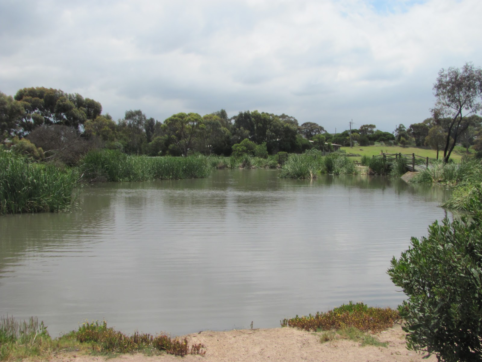
Moorabool River
Like the Barwon, the Moorabool has an east and a west branch which rise on the southern slopes of the Great Dividing Range between Ballarat and Ballan. The two branches meet outside the township of Morrisons after which the river flows to its confluence with the Barwon River at Fyansford.
Alarmingly, the Moorabool is one of the most environmentally stressed rivers in Victoria, with water being drawn from the river from the upper reaches of both the East and West Moorabool rivers, the Lal Lal Reservoir, Sheoaks and Meredith to supply water to Ballarat and Geelong. There is also a significant quantity of water used by farmers and other private operators. It has been indicated that at Batesford at the lower end of the river, environmental flow targets are met less than 50% of the time.
The removal of water from the system is not the only environmental factor affecting river health. The presence of a total of 15 water collection sites along its length impact greatly on the movement of native fish and other river fauna such as platypus whilst the loss of native vegetation for agricultural purposes and its replacement with non-native trees (such as willows) have also had a significant impact on river health.
Dog Rocks Hotel aka Batesford Hotel aka Derwent Hotel
But for now, back to today's adventure. Firstly, I went for a wander along the walking track through the Moorabool Nature Reserve which is located off Dog Rocks Road near the Moorabool Estate Winery. This short trail leads down to the river and then heads north, mostly keeping close to the river bank in the direction of Batesford. This section of the river is bordered by a combination of native and exotic plantings with farms close on either side. Unfortunately the path does not extend as far as the Batesford town which is a pity as it would be a nice walk to the pub for refreshments!
The start of the trail is adjacent to the Dog Rocks Flora and Fauna Sanctuary - an area of 83ha which has been preserved in its natural state by the Belcher family who bought the land in 1856. The sanctuary has river frontage to the Moorabool and is home to a wide variety of natve plant and animal life. The sanctuary is holding an open day within the next couple of weeks on 19th November, 2011. Details are on the above website.
After making my way along the river path and back in perfect, sunny weather, I headed back round to Batesford where I stopped at the pub and investigated the old bridge (I do love an old bridge!).
Batesford is named for the brothers Alfred and John Bates who settled in the district in 1837 at this site where the river could be forded, although the township (first surveyed in 1854) was originally named Hopeton for George Hope who then owned the land.
1859 bluestone bridge at Batesford
This impressive bluestone structure was built in 1859 to replace an earlier timber bridge, located a little above the ford which was built in 1846, destroyed the following year and then replaced in 1848. This structure was also damaged during the floods of 1852. The bluestone bridge is still in use today as part of a service road whilst the newer concrete and steel structure built in 1972 carries traffic on the Midland Highway immediately adjacent to the older structure.
The river is presently flowing along its length due to the rainfall of the past 12 months, however this has not always been the case, especially during the recent drought. For now however, it is lush, green and not too muddy.

05 November, 2011

The place to be!

The Barwon on a sunny day
It's amazing what a difference a few degrees in weather temperature can make - especially on a week-end. Today was just about the first 30 degree day of the season and a Saturday. Not surprisingly, every man and his dog (yes, literally) wanted to be on, beside or in the river and I was no exception. I was due for a run and knew it was going to be warm, so headed out at 8:30am to Queen's Park and back via Breakwater.
Water skiing
The little athletics crew were out early - but then, they would have been regardless of the weather. Quite a number of joggers were doing the same as me and getting in before the heat as were the cyclists and walkers, with or without dogs, iPods or walking buddies.
I completed my run in reasonable time given the warm conditions and headed home only to be tempted once again by the lure of river on such a pleasant day. So, armed this time with my camera, I headed back down to see who else was around. The rowers who had been much in evidence during my run - they need to install traffic lights  on the path during rowing season - had packed up and gone home for lunch. The little athletes were still cutting laps of Landy Field and the runners, walkers and riders were all still out in force even at the usually quiet Breakwater end of the walking track.
A picnic on the river
I say usually. Today however, this part of the river was anything but quiet. With good weather and week-ends come water-skiers and by the time I returned this afternoon, they were out in force. There must have been at least half a dozen power boats of varying size taking turns up and down what suddenly seemed a rather short stretch of river below the rowing course. The noise was less than peaceful - to say the least - and the backwash from the boats strong enough that I'd swear I saw a moorhen body surfing near the west bank. Despite this, the various boats all seemed to steer well clear of each other and their activities didn't seem to be worrying the bird life which is no doubt quite used to these warm weather invasions of their otherwise peaceful home.
Barwon Valley Golf Course
A particularly large group of skiers had set up and were having a picnic lunch during a break in proceedings whilst on the opposite side of the river, golf was the preferred pursuit. Overhead, some lucky tourist was taking in views of the river from an altitude which I have yet to achieve as the sea-plane circled overhead.
Nor were people the only ones making the most of the good weather. The birds as I mentioned were out and about, with one very vocal White-browed Scrubwren still managing to make itself heard over the boats, whilst a couple of the braver waterbirds were still opting for a swim despite the surf-like conditions.
White-browed Scrubwren
The bugs it seems were also out and about with a variety of bees and other beasties in evidence and from the rustling in the undergrowth, the reptilian population was possibly also enjoying the day.
Unlike the resident wild life, my window of opportunity was brief, so I snapped my photos, spent some time chasing the scrubwren through - yes - the scrub and then headed off to my other commitments.